i dk if you would call this cultural exactly, and its not about structures, but here's another interesting or at least quirky ohio one for urban planners that most people do not know about.
additionally, its fodder for conspiracy oriented folks!

sandusky -- laid out by the masons:
https://www.google.com/maps/@41.4427786,-82.6816344,12z
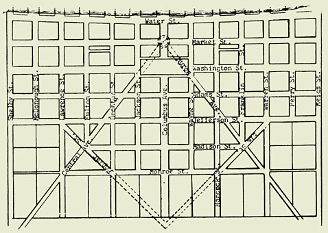
Laid Out in Form of Square and Compass
As far as I have been able to check in the past several years, Sandusky is the only city in the world originally laid out on Masonic symbols.
Hector Kilbourne, the first Master of Science Lodge No. 50, Sandusky in 1818, was the surveyor who made the original plan of the city. He proceeded with well-defined ideas and painstaking care in making the original survey as well as giving names to the streets in honor of the statesmen, warriors and others prominent in the early history of the country.
Brother Kilbourne in laying out the city ran the lines or streets in order to form a true representation of the Square and Compasses. This has been clearly shown in the accompanying illustration.
The original plan of the city, as here represented, may be said to represent an open Bible, Square and Compasses in correct position to proceed with labor upon opening the Lodge.
Taking Columbus Avenue as the center of the Book, the blocks and squares on either side of the avenue are equal in number and dimensions, excepting the twelve blocks along Water Street, which on account of the water or shore line indentation, slightly reduces the area of each block when compared with the other blocks south of the present Market Street. Master Masons well know the position of the Square and Compasses used in the Lodge room when in sessions.
https://freemasonry.bcy.ca/history/s.../sandusky.html